

NEWS
CEE-USV™ in Super Shallow Intertidal Zone for Wetland Project
3 February 2024
·
1 min read
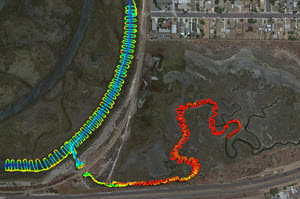
For a wetlands project in California, just north of the USA – Mexico border local survey firm Project Design Consultants needed to produce a topo map of an area of wetlands. While their drone survey was able to handle the exposed areas, the presence of narrow winding tidal salt-water channels created a problem. Impossible to safely wade for manual measurements, the wetlands presented an opportunity to blend the terrestrial data with USV-generated bathymetry. Using their own Trimble R12 on the CEE-USV™ for position, the shallow draft vessel was just about able to navigate up the main channel and fill in the missing parts of the survey. Data were recorded inside the CEESCOPE™ and later uploaded and processed using Hydromagic software.

Equipment used
Talk to US
Planning a survey? Talk to our team.
Our engineers can help you choose and set up the right echo sounder, tide gauge or USV for the job.