

Knowledge base › Survey guide
Survey guide
What should I know before surveying with the CEE-LINE™?
Mount the transducer as shallow as you can without dragging air under it, keep it vertical and turn off the boat’s own sounder. In CEE-LINE CONNECT set blanking to the minimum, max depth about 50% deeper than expected, and no draft if the antenna offset is in your data collector. Use SHALLOW mode for work under 5 m, and remember draft plus blanking is the shallowest you can measure.
10 pings per second
30 / 90 cm min blanking, 200 / 33 kHz
+50% max depth over expected
<5 m use SHALLOW mode
Without a few key concepts, it’s easy to get poor data: from how the equipment is set up on the boat, the settings chosen, or not knowing about critical environmental factors. These points apply to shallow water surveys with the CEE-LINE™ connected to a GNSS data collector.
The CEE-LINE™ sends 10 pings per second, usually at 200 kHz, measures the time to the echo, and outputs the depth continuously. In very shallow water it gets more complicated, for three reasons:
- The ping keeps bouncing between surface and bottom, depending on its “volume”, so multiple echoes can interfere.
- No transducer can listen straight after pinging. That wait time is the blanking distance: if the bottom gets too close, it becomes invisible.
- Air absorbs sonar very efficiently, so there can’t be air under the transducer.
The CEE-LINE™ constantly adjusts to track the bottom, and a poor set-up can hurt the results.
How should I install it on the boat?
- As close to the surface as possible, to maximise the measurable depth range. The distance from the water surface to the black urethane transducer face is the draft.
- No air under the transducer. Set it just deep enough to avoid bubbles, which show as zero-depth spikes. Air increases with speed, so data may look fine at set-up and get worse at survey speed without anyone noticing.
- Vertical, or as close as possible. The beam width allows some pitch and roll without losing accuracy.
- Boat echo sounders must be off. A recreational sounder adds random noise: occasional depths anywhere between zero and the max depth setting, unrelated to the bottom.
- Clean power. Electrical noise is rare, but most likely when high-current motor controllers share the power line, for example on an RC boat.
How do I set it up in CEE-LINE CONNECT?
Usually you set it once and leave it until you survey somewhere very different. The USB cable creates a COM port, and AUTO baud rate connect finds the echo sounder. Default baud rate is 9600.
| Setting | Recommended | Why |
|---|---|---|
| Output | Single frequency: NMEA $SDDBT (no draft). Dual frequency: DESO25 (includes draft) | Recommended defaults for a data collector. |
| Pings per second | 10 | Minimises latency with GNSS data. |
| Blanking distance | Minimum allowed: about 30 cm / 1 ft at 200 kHz, 90 cm / 3 ft at 33 kHz | The bottom is invisible inside it. |
| Max depth | About 50% more than the deepest expected | Below it there’s no valid data, only noise. A tight limit keeps bottom tracking consistent, especially in shallow water. |
| Draft | 0 if your data collector already has the transducer-to-antenna offset | Otherwise the draft is counted twice. |
| Sound velocity | 1500 m/s if unknown | Lets you correct depths later; otherwise enter the real value and note it in the survey log. |
| Time variable gain | Off | |
| Index | 0.00 | |
| Frequency | 200 kHz (high) or 33 kHz (low) |
Click Save Settings to Device after changes. Don’t press Reset. For a device-by-device guide, see TSC7 or Carlson SurvCE.
AUTO, SHALLOW or MANUAL?
| Mode | Use |
|---|---|
| AUTO | Standard bottom tracking from 0.3 to 100 m (1–330 ft). Use in all cases except below. |
| SHALLOW | Auto tracking at low power, for surveys under 5 m (16 ft) where much of the data is near the minimum depth. Reacquires the bottom faster after losing it. |
| MANUAL | Lets you change pulse width, gain and detection. Needs hydrographic software: don’t use it with a GNSS data collector. |
Down to draft plus blanking, AUTO and SHALLOW track into very shallow water about equally well. After losing the bottom in the blanking zone, SHALLOW finds it again faster. In AUTO, slow down slightly to shorten the distance needed to regain tracking.
What happens when the bottom enters the blanking zone?
The shallowest measurable depth is draft + blanking, wherever the draft is entered. Once the bottom rises into that zone, the echo sounder has no real data, and the nearest return is the first double echo at twice the depth. The 10 Hz trace jumps from the bottom to 2× depth until the boat is back in deeper water: a double echo “volcano”. In reality results near the zone can scatter like noise as it switches between multiple echoes, and it takes longer to lock back on.
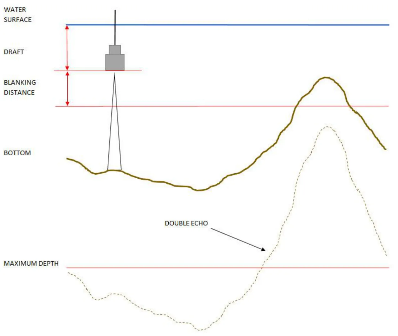
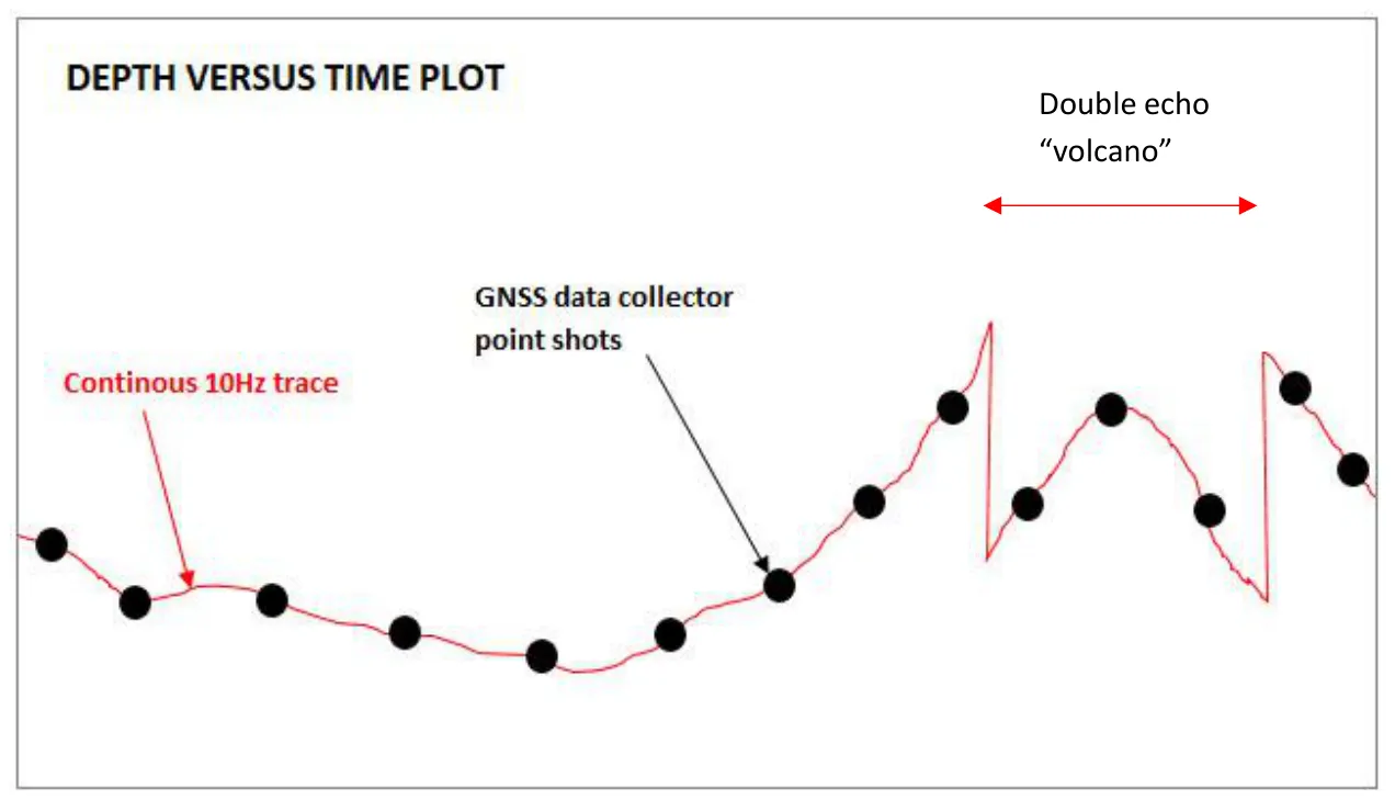
A data collector can hide it. At about 1 Hz point shots you won’t see the “volcano”; the double echo may be completely overlooked. Data in elevation rather than depth makes it harder too: it’s easier to spot 0–6.5 ft depth than 486–479.5 ft elevation. You can’t do a meaningful survey where much of the area is in the blanking zone, so reduce the transducer depth on the boat.
Under normal operation the CEE-LINE™ shouldn’t lose the bottom within its specified depth range. Occasional zero spikes (debris, bubbles, crossing a wake) and occasional double echo spikes are normal, but should be under 1% of the data unless there’s an installation problem.
Special situations
- Dual frequency: the 33 kHz blanking zone is much wider, so low frequency data is of little or no value in under about 1 m (3 ft) of water.
- Hard bottoms (concrete impoundments, plastic-lined pits): multiple echoes can be unusually strong. Set max depth only about 25% deeper than expected to cut spikes from the first multiple.
- Vegetation: echo sounders can’t automatically tell the real bottom from the canopy. Use a data collector with caution, at the maximum sample rate. See surveying in vegetation and hydrographic vs land survey set-ups.
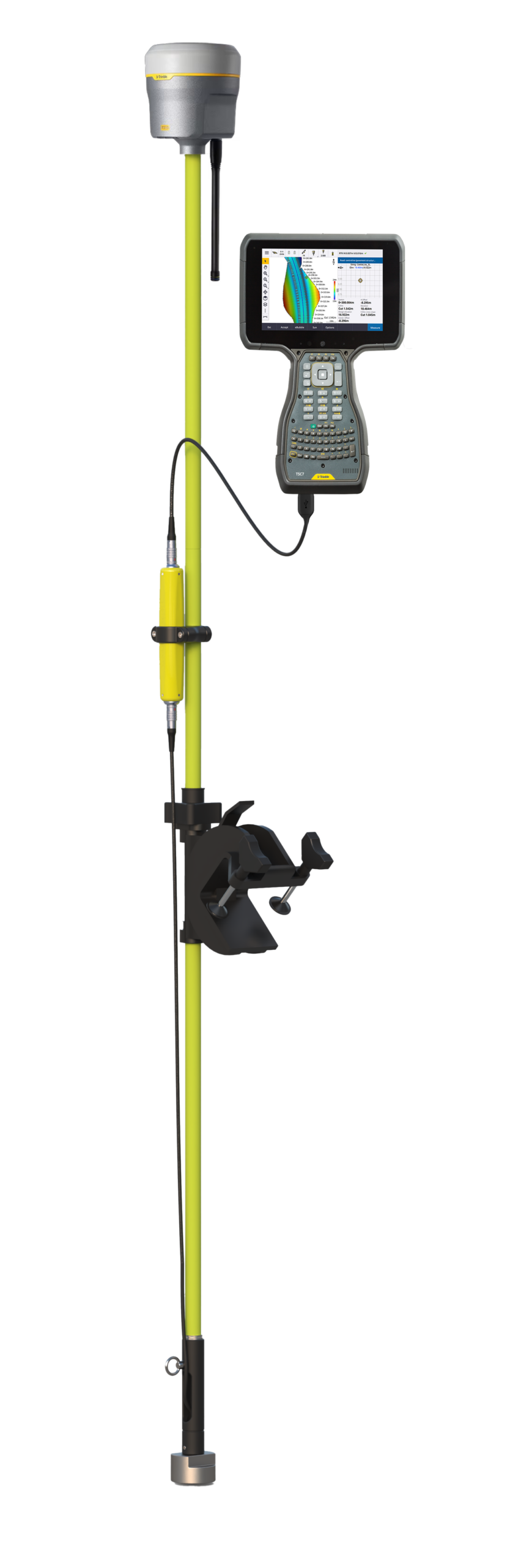
Equipment used
Talk to US
Need a hand with your set-up?
Our engineers answer survey questions every day.