Customer stories from around the world
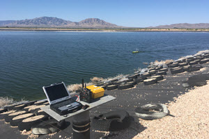
Automated Power Station Fly Ash Pond Surveys with the CEE-USV™
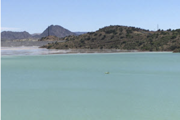
The CEE-USV™ was used to determine water and ash volumes for three power station fly ash lagoons in the Southwestern USA. The robotic CEE-PILOT™ autopilot effected some spectacular survey lines on the larger ponds resulting in a survey product with a high degree of confidence and accuracy. Operating the USV with a manual pattern using real time aerial drone video to avoid hazards was used for two irregular smaller ponds. LEARN MORE
CEE-LINE™ Used for Bridge Engineering Surveys in Germany
After experiencing unsatisfactory performance from some basic pole mounted echo sounders, surveyors working in Upper Bavaria, Germany turned to the CEE-LINE™ for their on-water surveys. Working in the Trimble data collection environment with TSC3 and TSC510 data collectors and surveying mainly on bridge scour projects, datasets generated using the CEE-LINE™ were consistent, repeatable and trustworthy. LEARN MORE
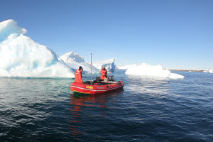
Surveying with the CEESCOPE™ in the Coldest Place on Earth
As part of an Australian government initiative to build the first paved runway in the Antarctic continent at the country’s Davis Station base, a survey team was dispatched to conduct hydrographic surveys in the waters near the proposed new aerodrome site. CEESCOPE™ Single beam bathymetry and CEE-TSF™ enhanced StarFish side scan imaging were combined to give project managers a view of the potential challenges for operating landing craft during the construction phase of the project. LEARN MORE
CEESCOPE™ Guides YWAM Medical Ship MV Pacific Link through Uncharted Rivers in Papua New Guinea.
In order to bring a medical ship safely up river through completely uncharted territory, a survey launch was equipped with a CEESCOPE™ system. High speed single beam hydrographic surveys were conducted ahead of the YWAM medical ship MV Pacific Link to allow a safe course to be navigated. With no survey infrastructure existing, the all-in-one echo sounder and GPS was the ideal solution. YWAM provide health and dental care to remote communities only accessible by river.. LEARN MORE
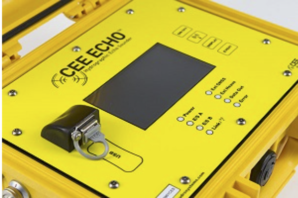
CEE ECHO™ Replaces Traditional Echo Sounders for Hughes & Associates, Alaska USA.
Surveyors at Hughes & Associates really started appreciating what modern single beam equipment can do during their first survey season using the CEE ECHO™. We were happy to hear that their other sounders were put into retirement resulting from the clean data and super-accurate bottom tracking obtained with the CEE ECHO™. Knob twiddling and manual gain adjustments are now a thing of the past. LEARN MORE
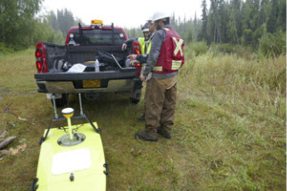
CEE-USV™ Surveying the Trans Alaska Pipeline System with Alyeska Pipeline, Alaska USA.
The CEE-USV™ including the CEESCOPE-LITE™ echo sounder with Trimble RTK GNSS was introduced to perform depth of burial surveys along the Trans Alaska Pipeline System (TAPS) in 2018. Now you can read more details about this “textbook” application of a USV hydrographic survey system where restricted access, remote locations, and swift water conditions make a high-performance USV approach ideal. LEARN MORE.
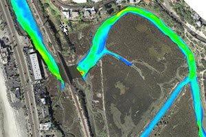
CEE-ECHO™ Used for Very Shallow Surveys in Major San Elijo Lagoon Restoration Project, San Diego USA.
Coastal engineering and surveying experts Coastal Frontiers Corporation invested in a new CEE ECHO™ for a multi-year project supporting the San Elijo lagoon habitat restoration project. With much of the hydrographic survey element taking place in under 4ft (1.2m) of water, performance of the echo sounder in the tricky shallow water environment was critical. Monitoring dredging activities and beach nourishment, the benefits of the CEE ECHO™ were clear. LEARN MORE.

CEE-ECHO™ Enables In-House Marine Construction Firm's Dredging Progress Surveys, Northeast USA.
Atlantic Coast Tug and Marine, LLC (ACT Marine) kindly supplied a testimonial commentary on their successful implementation of a new CEE ECHO™ survey system for improved quality control and accuracy for grade verification. LEARN MORE.
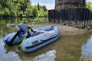
CEE-LINE™ Enables Shallow Canadian River Surveys with Midwest.
Faced with a survey project in the remote poorly accessible Red Deer River flowing through Alberta and Saskatchewan, engineering firm Midwest added the CEE-LINE™ single beam echo sounder kit to their Trimble TSC7 and R12i GNSS-based data acquisition setup. The CEE-LINE™ was installed on an inflatable raft that was paddled up the river with survey depths often just a few inches below the transducer.LEARN MORE.
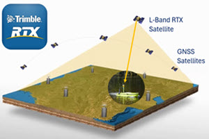
Trimble RTX Enables Accurate Wastewater Sludge Monitoring.
Minnesota, USA based Team Laboratory Chemical Co. offer integrated wastewater effluent services including bathymetry surveys to evaluate accumulated sludge levels. Their survey method required a manual measurement of the water height using a range pole in the middle of each lagoon, so measured depths could be translated into sludge heights. To eliminate this requirement and improve reliability of ongoing treatment evaluation, the Teamlab CEE-USV™ was upgraded to include a CEESCOPE™ with integrated Trimble 9250 GNSS receiver with CenterPoint® RTX. With vertical accuracy of 2.5cm (1") the RTX water elevation data can be recorded automatically, eliminating the need for relatively inconsistent manual measurements. LEARN MORE.
CEETIDE MAX™ Provides Reliable Tide Monitoring in Gippsland Ports, Victoria Australia.
In the third year of steady operation, Gippsland Ports in Australia gave the CEETIDE MAX™ a big thumbs-up for exceptional reliability and ease of use. By selecting the tide gauge option that incorporated a precise Trimble GNSS receiver, port managers can ensure their data are secure for long term use with continuous monitoring of the exact position of the sensor structure. All tide data are made available through a web server facilitated by the CEETIDE MAX™ internet connectivity. LEARN MORE.
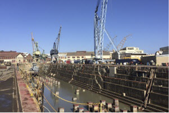
RTK CEESCOPE™ Used for Historic Naval Dockyard Surveys, California USA.
Grounding of a vessel leaving dry dock would be a disaster for the vessel operator and the dock owner. To prevent these events, dry dock operators diligently monitor sediment conditions around the docks. Mare Island Dry Dock (MIDD) gained flexibility to conduct their own surveys whenever needed with the RTK CEESCOPE™ echo sounder package. Using HYPACK® software with local cell-phone corrections from the California Real Time Network, MIDD can generate precise hydrographic surveys with a turnaround time of just one day. LEARN MORE
CEE ECHO™ Used for Precise Construction Hydrographic Survey after Florida Hurricane.
Central Florida, USA land surveyors Area Of Interest (AOI) Inc, had conducted occasional hydrographic surveys using rented basic pole-mounted echo sounders over recent years. Data quality was often questioned and often AOI resorted to manual pole or line soundings so their surveyors could trust datasets provided to their clients. To improve efficiency and get back to a sonar measurement, AOI invested in the CEE ECHO™ package with Hydromagic software and had a revelation in terms of their data quality and usability compared to previous efforts. And realized an enormous time saving too. LEARN MORE
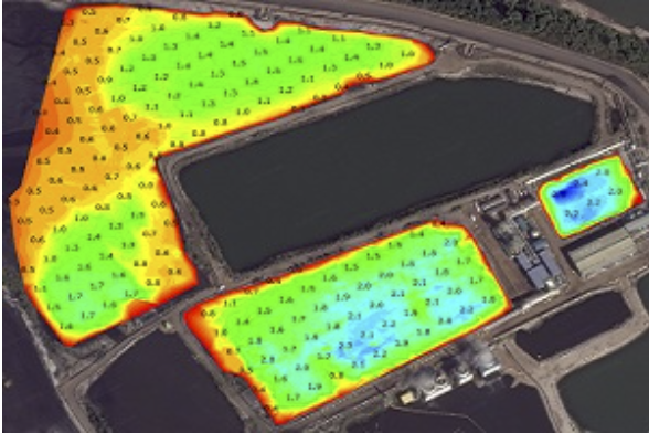
Manned and Unmanned Effluent Lagoon Surveying in Southern USA.
Louisiana-based Environmental Business Specialists (EBS) started a program of industrial effluent lagoon sludge mapping using the dual frequency CEESCOPE™ echo sounder with HYPACK acquisition software. After the success of their manned-boat program, and with increasing calls from clients to move to an unmanned boat, EBS substantially enhanced their toolbox with a CEE-USV™ remotely-operated survey boat. LEARN MORE
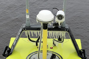
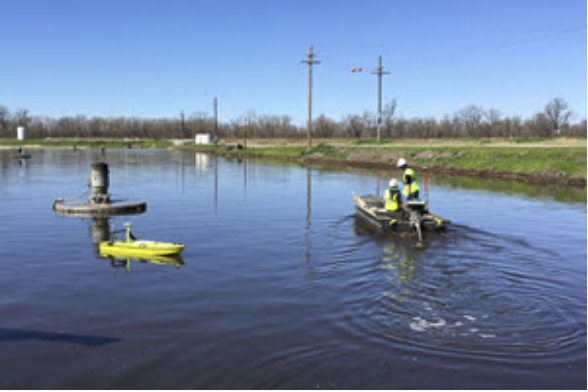
CEE-USV™ Icy Test in the Midwest.
Early in the survey season in Northern Minnesota, USA it can be tough on equipment. With winds gusting to 45mph and sub-zero temperatures, this CEE-USV™ wastewater effluent lagoon survey was a challenge for the equipment. While the effluent water was heated and largely not frozen, everything else fast became caked with ice. LEARN MORE
CEE ECHO™ Replaces Traditional Land Survey Methods for Small Scale Surveys.
Florida, USA survey engineers moved away from time-consuming land survey methods for commercial and residential permitting hydrographic projects. Using dedicated single beam Hydromagic software and their existing Trimble R780 GNSS receiver with the CEE ECHO™, significant improvements in fieldwork efficiency were realized – even for small project areas. LEARN MORE.
Municipal Wastewater Surveying with the CEE-USV™ Monitoring Sludge Mitigation Treatments.
TEAM LAB Chemical instituted a remotely-operated survey boat program for ongoing repeat surveys of wastewater lagoons. With 130 surveys per year and growing, the bathymetry team are able to show lagoon operators the true sludge volume in effluent lagoons by using the combination of the CEE-USV™ and Eye4Software Hydromagic hydrographic acquisition software. When treated with the firm's biological remediation agents, sludge reduction may be quantified to allow the operator to understand the return on investment of the treatments compared to expensive mechanical removal. Considering snow and ice covers the region for much of the year, surveyors are very busy over the summer months! LEARN MORE.
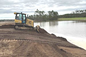
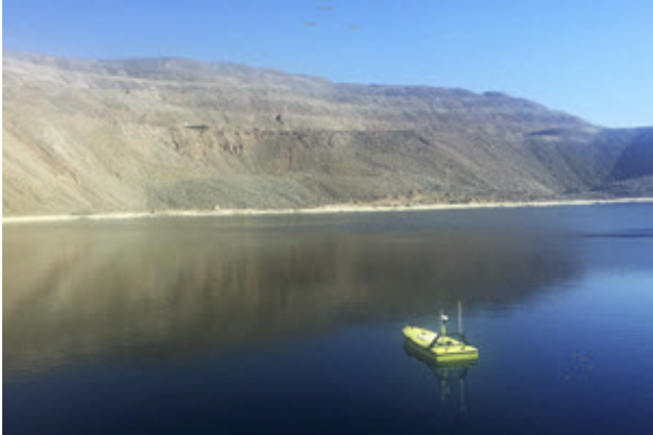
Copper and Gold Mine Tailings Surveying in North America
In possibly the best unmanned surveying application of all, the CEE-USV™ has found plenty of use in mine tailings impoundments in the United States and Canada. As the mine operators would much rather not have personnel on the water, an unmanned solution is an ideal approach. However, the tailings environment has challenges; large areas with treacherous beaches and potential for mountain winds-generated wave chop call for a professional vehicle. LEARN MORE.
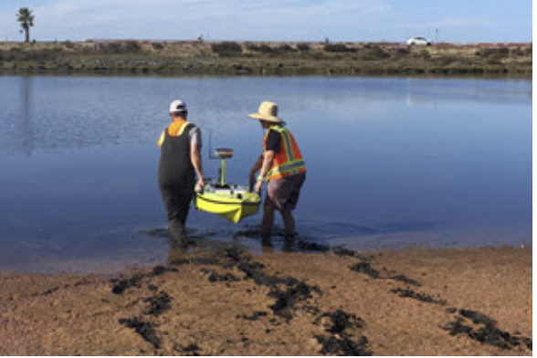
CEE-USV™ Used for Extreme Shallow Water Coastal Lagoon Survey.
The CEE-USV™ saved a lot of time and trouble in San Diego, USA. Staff at Coastal Frontiers Corp were faced with a shallow water survey where no conventional manned boat could be launched and the mud prevented any wading to collect point GNSS elevation shots. However with the 10cm (4″) draft CEE-USV™ the survey was completed in just a couple of hours . LEARN MORE

Rapid Mobilization CEESCOPE™ and Side Scan Survey Kits for Royal Australian Navy
To meet specific RAN deployment requirements, CEE HydroSystems has developed the self-contained Rapid Mobilization CEESCOPE™ Hydrographic Survey System. With ruggedized packaging and enhanced power packs, a highly modified Tritech StarFish side scan topside, an RTK CEESCOPE™ and portable transducer mounting hardware included in each kit, the new equipment will be used for shallow water survey duties from light utility boats deployed from survey ships or landing craft, or vessels of opportunity. LEARN MORE.
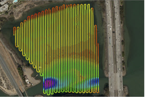
CEE-PILOT™ Robotic Navigation for Ultimate Survey Results.
In addition to reducing the operator workload and generating remarkable survey line patterns, the use of the CEE-PILOT™ autopilot system also directly benefits the hydrographic survey deliverable accuracy. In a coastal lagoon survey, the benefits in terms of data consistency are clear. LEARN MORE.
CEE-ECHO™ Selected for BayLand Consultants & Designers’ Hydrographic Services in the Chesapeake Bay, USA.
Maryland, USA engineering and environmental services firm BayLand Consultants & Designers, Inc. selected the CEE ECHO™ single beam survey system for use with their Trimble GNSS equipment. Primarily for projects in the Chesapeake Bay, with a focus on shallow water environments and high precision, BayLand made a step forward in hydrographic hardware and acquisition capabilities, also using HYPACK software. LEARN MORE
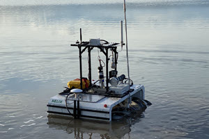
CEE-ECHO™ Used on Unique Copperstone Technologies HELIX Mine Survey Robot.
Edmonton-based robotics firm Copperstone Technologies enlisted CEE's help to develop a single beam echo sounder capability for their HELIX robots. Powered by an unusual screw-drive that allows the vehicle to traverse almost any terrain, the HELIX may be used to conduct volume surveys of the tailings impoundment and other industrial water environments. The CEE ECHO™ 33/200 kHz was a perfect fit for the robot. LEARN MORE
CEE-USV™ Completes Site-Wide Mine Tailings and Acid Leach Pad Reservoir Survey.
The CEE-USV™ was used to complete the first every bathymetry survey of the tailings impoundment at the Ray open pit mine in Arizona, USA. In addition, hazardous sulfuric acid leach pad reservoirs were also surveyed. Reliability was the key factor with no means of rescue or recovery from the acid ponds or TSF! LEARN MORE
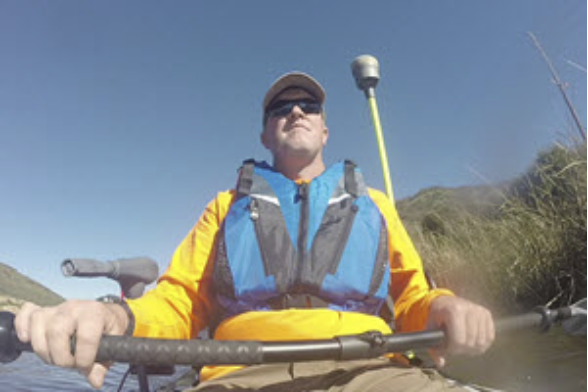
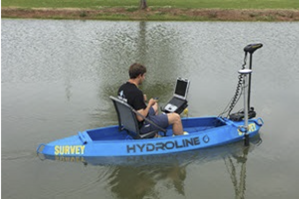
CEE-LINE™ Used for Dam Bathymetric Survey with Trimble GNSS.
The CEE-LINE™ was the ideal solution for a kayak survey of a dam reservoir near Los Angeles, California USA. Easy and fast to mobilize, the CEE-LINE™ provided just the right level of accuracy and convenience for the small scale survey conducted by the land survey crew. LEARN MORE
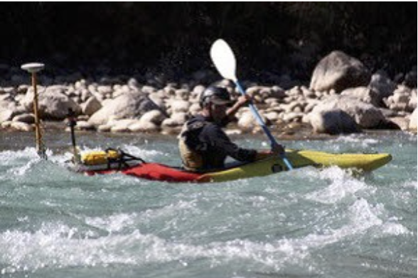
CEESCOPE™ RTK Used for Extreme River and Rapids Surveys in Bhutan.
The CEESCOPE™ was selected for a tough assignment surveying shallow fast-flowing rivers and rapids in Bhutan as part of a development aid-funded project to evaluate the environmental impact of existing and future hydropower installations. The waterproof echo sounder enclosure and the ability to record high quality, densely spaced 20Hz RTK quality soundings turned out to be crucial. The surveyors had enough to worry about without having to operate an echo sounder or GPS! LEARN MORE
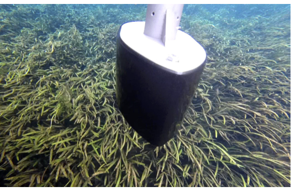
WaterCube use CEE ECHO™ Dual Frequency Echo Sounder to map Florida River with Extreme Vegetation
Use of the CEE ECHO™ in combination with the Hemisphere Atlas™ GNSS allowed a successful reconnaissance survey of the Silver River in Florida. The goal was to determine whether it was possible to gather usable bathymetry in this shallow environment with almost total sub aquatic vegetation coverage. With the real time 200 kHz echo sounder effectively mapping the top of the vegetation, post processed 33 kHz and 200 kHz data identified of the real bottom beneath, allowing determination of plant height and coverage. LEARN MORE
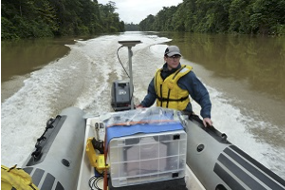
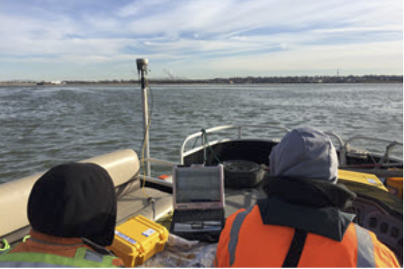
USGS Use CEESCOPE™ and CEE ECHO™ for SW USA River Groundwater Study
Hydrologists at the United States Geological Survey conducted an extensive groundwater study along nearly 900 km (550 miles) of rivers in the southwest USA – Mississippi Alluvial Plain. While the main survey instrument was a towed array measuring continuous resistivity, positioning and bathymetry inputs were provided by CEE instrumentation. The use of L-Band GNSS corrections (Precise Point Positioning) was a convenient way to obtain approximate water elevation throughout the field work. LEARN MORE.
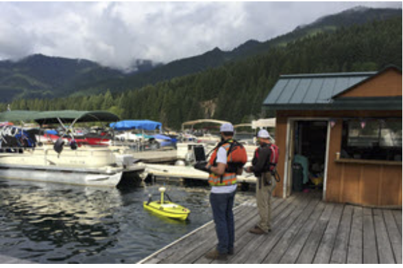
Statewide Land Surveying use Remotely-Operated CEE-USV™ for Marina Surveys
Statewide Land Surveying in Gresham, Oregon USA used their new CEE-USV™ remotely-operated hydrographic survey drone boat for a pre-dredge survey at Detroit Lake, OR. Both marinas at the lake were surveyed and the access benefits of using the USV resulted in thorough coverage of the target area. The CEE-USV’s network telemetry meant the operator was able to drive the boat from the dock using a navigation display while the surveyor at the shore station could simultaneously review data collected. LEARN MORE
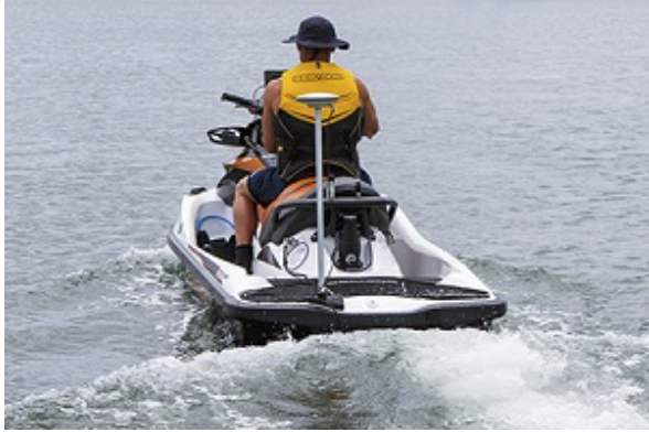
City of Gold Coast use CEE JET™ Turnkey PWC Survey Vehicle for Beach Nourishment Measurements
The CEE JET™ personal watercraft (PWC) hydrographic survey vehicle allows surveyors at Australia’s Gold Coast City Council to replace laborious leveling measurements with a CEESCOPE™ echo sounder and RTK GNSS bathymetry system to get surf zone elevation measurements on some of the oldest continuously measured beach nourishment study transects in the world. LEARN MORE
Canada Pump and Power Use CEESCOPE for Effluent Pond Dredge Surveys
For a new industrial water bathymetry survey capability, Canada Pump and Power chose the CEESCOPE™ to start off their new surveys. Working in support of dredging projects to clear accumulated effluent sludge in industrial and tar sand mining processes, the CPP survey crew are able to conduct fast surveys with no headaches setting up the gear. With a dual frequency echo sounder and professional hydrographic software, CPP are able to offer a complete solution for their clients. LEARN MORE
Hydroline LLC Use CEESCOPE for Frac Water Surveys
In combination with advanced HYPACK® software, Louisiana-based Hydroline LLC use the CEESCOPE™ “all in one” survey system to offer high quality oilfield frac water surveys. The use of professional grade hydrographic equipment allows Hydroline to generate industry-leading surveys of pit and pond volumes, and generate precise stage versus volume curves. LEARN MORE
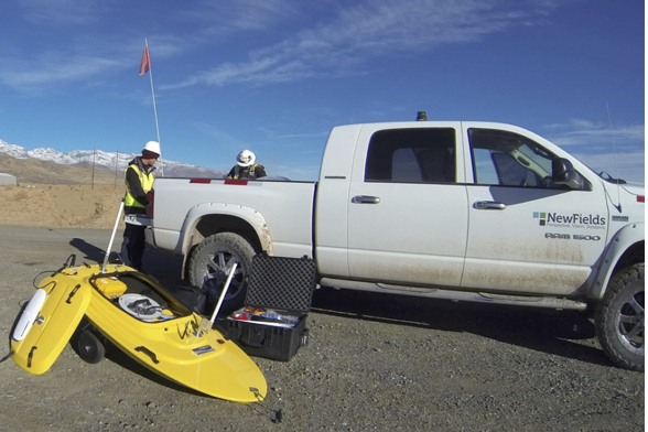
NewFields use Remotely-Operated USVs Based on CEE ECHO™ Echo Sounder
The CEE ECHO™ single beam echo sounder is exceptionally well suited to integration into remotely-operated or autonomous hydrographic survey boats. NewFields use a CEE ECHO™ on their USV for surveys in mining, industrial water, lakes, and the coastal environment in North and South America. Using HYPACK® NewFields are able to map tailings deposition and settling using the low frequency echo sounder channel. LEARN MORE
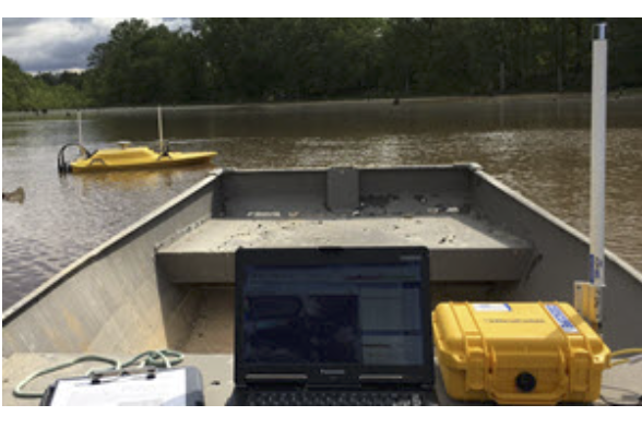
NewFields Upgrade to RTK CEESCOPE for USV Surveys
NewFields has been using CEE echo sounders on USVs since 2014. To improve usability and flexibility of their latest USV fleet addition, the RTK CEESCOPE™ was selected with the special USV modification including the CEE-LINK™ shore radio module. Working with their UHF base station or CORS corrections, the newest USV configuration eliminates complexity and potential for downtime inherent in their older USV technology. LEARN MORE